
Table of Contents
Local search engine optimization has relied on the exact same playbook for more than fifteen years. Most website builders simply pick a target city name, add a postal zip code, list a street address, and write a few predictable sentences about local service areas. That basic method worked well when search engines were simple directories. Today, search engines function as semantic reasoning engines. They do not just match strings of text; they examine entities, physical relationships, and real world geography.
When we build digital spaces that reflect real world systems, we uncover a much better way to prove geographic relevance. Nature does not organize itself by arbitrary political lines, county borders, or zip codes. Land organizes itself into drainage basins, river valleys, and living catchments known as watersheds. When web platforms connect their local pages to live species feeds, they tie digital code directly to physical ecology.
By integrating live species feeds into your local content architecture, you provide search engines with authentic geographic proof. You are no longer just asserting that your organization operates near a specific creek or river basin. Instead, you demonstrate that reality by streaming validated biological observations, water quality metrics, and seasonal flora changes directly into your structured web documents. This biophilic approach unites computer science, environmental biology, and technical search strategy into an authoritative digital asset.
                    +------------------------------------+
                    |  Real-World Ecological Indicators   |
                    | (Flora, Fauna, Macroinvertebrates) |
                    +------------------------------------+
                                      |
                                      v
                    +------------------------------------+
                    |   Biological Data Sources & APIs   |
                    |      (GBIF, iNaturalist, USGS)     |
                    +------------------------------------+
                                      |
                                      v
                    +------------------------------------+
                    |  Edge Caching & Server Hydration   |
                    |      (SSR / ISR HTML Generation)   |
                    +------------------------------------+
                                      |
                         +------------+------------+
                         |                         |
                         v                         v
        +---------------------------------+  +-------------------------------+
        |   Semantic JSON-LD Metadata     |  |   Calm, Biophilic Visual UI   |
        | (Schema: Taxon, Place, Context) |  |  (Accessible Environmental UI)|
        +---------------------------------+  +-------------------------------+
                         |                         |
                         v                         v
        +---------------------------------+  +-------------------------------+
        |  Search Engine Entity Graph     |  | Human Reader Trust & Dwell    |
        |  (Authority, Hydrologic Anchor) |  | (Engagement, Low Bounce Rate) |
        +---------------------------------+  +-------------------------------+
The Paradigm Shift: Moving Beyond Static Geographic Markers

Traditional search marketing focuses on municipal borders. A business creates distinct landing pages for every town in a metropolitan region, changing only the town name while leaving the rest of the text unchanged. Search engines recognize this low effort tactic and often filter out or devalue these repetitive pages.
Land exists as a continuous fabric shaped by water flow. A watershed is an area of land where all rainfall, melting snow, and runoff drains into a shared body of water, such as a creek, wetland, lake, or river. Every point on Earth sits within a specific catchment basin.
When your website shifts its geographical focus to water catchments, you align your content with the foundational framework used by environmental scientists and regional planners. Modern search crawlers understand these natural systems. They maintain vast entity catalogs derived from databases like Wikidata, GeoNames, and federal geographic registries.
Using live species feeds connects your digital content to these natural systems. When you display real-time observations of native willow trees, returning songbirds, or emerging dragonflies along a specific river corridor, you present distinct, living evidence of locality that automated content spinners cannot replicate.
Political Model (Static & Saturated):
[ Domain ] ---> [ Target City ] ---> [ Zip Code ] ---> (Generic Keyword Repetition)

Hydrological Model (Living & Distinct):
[ Domain ] ---> [ Catchment Basin ] ---> [ Live Species Feeds ] ---> [ Authoritative Geo-Entity ]
Defining the Mechanism: How Real-Time Wildlife Telemetry Signals Hyperlocal Relevance
To understand why live species feeds work, we must examine how modern search bots crawl, render, and index web pages. Search engine crawlers operate on a crawl budget, allocating processing resources based on page value, update frequency, and informational trust.
When a standard local business page sits unchanged for two years, crawlers visit it infrequently. The page remains static, offering no fresh information. However, when you integrate live species feeds into your architecture, the content updates automatically in response to natural phenomena:
- A spring thaw brings rising stream levels, recorded by nearby hydrologic monitoring stations.
- Warming water triggers the emergence of stonefly and caddisfly nymphs along gravel stream beds.
- Community naturalists photograph and log native wetland plants, such as marsh marigolds or swamp milkweed, through mobile ecological applications.
When your web server converts these live species feeds into fresh page content, search engines recognize a dynamic, locally maintained publication. The updates are not random keyword stuffing; they are verifiable observations tied to specific regional coordinates.
Live species feeds provide factual, third-party corroborated data points. Because the species logged in live species feeds require precise microclimates to survive, their recorded presence confirms your site’s geographic context through biological indicators.
The Biophilic Thesis: Elevating User Dwell Time and Algorithmic Topical Authority
Biophilic design centers on the innate human affinity for the natural world. In website development, biophilic design moves beyond simply adding leafy green backgrounds or nature photography. It focuses on incorporating the rhythms, cycles, and visual structures of the physical world directly into digital interfaces.
+-------------------------------------------------------------------------+
| Biophilic Digital Principle | Technical Mechanism                       |
|-----------------------------|-------------------------------------------|
| Natural Information Rhythms | Phenological data updates via live feeds  |
| Visual Coherence & Order    | Hierarchical schema matching natural taxonomy|
| Grounded Geographic Context | Hydrologic unit codes (HUC) coordinate pins |
| Environmental Sensory Calm  | Real-time ambient ecological water metrics|
+-------------------------------------------------------------------------+
When visitors land on a page that features live species feeds, their browsing behavior changes. Instead of leaving immediately after glancing at an address, they pause to explore the natural activity unfolding around them:
- They observe which native birds were recorded in their local park this morning.
- They view live water temperature data for their local trout stream.
- They learn which wild wildflowers are currently in bloom along nearby public trails.
This engagement increases user dwell time and lowers bounce rates. Search engines monitor these user engagement signals. When a visitor spends two or three minutes exploring a page, search algorithms infer that the resource successfully answered the user’s intent.
By using live species feeds, you build genuine topical authority. You create a helpful community resource that serves both human readers and search engine crawlers.
Geo-Entity Triangulation: Connecting Hydrologic Unit Codes to Standard Schema
To maximize the search value of live species feeds, you must translate biological information into structured data that machines can parse effortlessly. The United States Geological Survey organizes all water drainage into a standard system called Hydrologic Unit Codes, or HUCs.
HUC Level  | Name               | Approximate Scale       | Example
-----------|--------------------|-------------------------|---------------------------
HUC-2      | Water Resource Region | Major Landmass Drainage | Mid Atlantic (Region 02)
HUC-6      | Basin              | River Basin System      | Upper Susquehanna (020501)
HUC-8      | Subbasin           | Regional River Valley   | French Creek (05010004)
HUC-12     | Subwatershed       | Local Stream Catchment  | Muddy Creek (050100040302)
A HUC-8 or HUC-12 code provides an exact boundary for a local stream or river system. When you configure your site’s backend, you can connect these hydrologic codes directly to municipal entities using Schema.org microdata:
- Connect your commercial or organizational address to standard administrative zones, such as towns, cities, and counties.
- Connect your physical coordinates to the encompassing watershed using the
PlaceorRiverBodyOfWaterschema types. - Link these records to external knowledge databases, such as Wikidata and GeoNames, using the
sameAsproperty.
By anchoring your live species feeds to both political boundaries and hydrologic units, you perform geo-entity triangulation. You give search crawlers two independent, verifiable methods to locate your services in physical space.
Freshness Signals Without Spam: Automated Ecological Logs as High-Utility Content
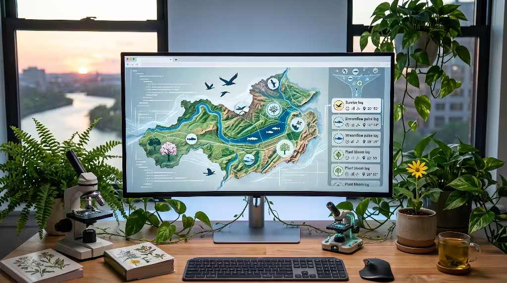
A common pitfall in search engine optimization is generating thin or repetitive text simply to make a page appear recently updated. Search algorithms actively detect and penalize low-quality automated text.
Live species feeds provide a reliable alternative because they deliver genuine scientific utility. When you publish data points from live species feeds, you share verified, crowdsourced biodiversity observations:
- The scientific name and common name of the observed organism.
- The exact timestamp of the observation.
- The general location coordinates, adjusted safely for conservation privacy.
- Diagnostic life-stage details, such as flowering, fruiting, or nymph stages.
Search engines treat this incoming stream of live species feeds as high-utility informational data. Because each record in these live species feeds reflects an actual physical occurrence, the resulting updates are authentic and valuable. You gain consistent, automated content freshness without resorting to artificial text spinning or repetitive keyword patterns.
Algorithmic Trust: Grounding Your Site in Reputable Global Repositories
Search engine quality guidelines emphasize experience, expertise, authoritativeness, and trustworthiness. A website cannot simply invent facts; it must cite reputable sources.
When you stream live species feeds, your web platform connects directly to recognized environmental data infrastructure:
- The Global Biodiversity Information Facility (GBIF): An international network funded by world governments to provide open-access scientific data about life on Earth.
- iNaturalist: A joint initiative of the California Academy of Sciences and the National Geographic Society that catalogs community-verified field observations.
- The USGS National Water Information System: The federal standard for United States water resource data, stream flow rates, and river depths.
- NatureServe: A respected conservation network that establishes standard conservation status ranks for North American flora and fauna.
[ Your Local Web Application ]
         |
         |---> Queries via REST / JSON:
         |
         +===> iNaturalist API (Species Observations & Taxon IDs)
         +===> USGS NWIS API (Water Flow, Gauge Height, Temperature)
         +===> GBIF Network API (Global Biodiversity Verification)
When your digital platform references external identification numbers from these trusted repositories, search crawlers notice those authoritative connections. By parsing your live species feeds, search engines recognize that your domain integrates with reputable scientific nodes, which elevates the algorithmic trust of your entire website.
API Selection and Rate Limiting: Navigating Environmental Data Networks
Building an effective system around live species feeds begins with selecting the appropriate application programming interfaces, or APIs. Each environmental data provider maintains distinct technical requirements, access rules, and payload formats.
+------------------+------------------------------------+--------------------------+
| Data Source      | Primary Strengths                  | Key Consideration        |
|------------------|------------------------------------|--------------------------|
| iNaturalist API  | High-density community observations| 60-100 requests/minute   |
| USGS Water API   | Official flow, height, temperature | High uptime, strict REST |
| GBIF API         | Museum-grade research collections  | Extensive taxon trees    |
| eBird API        | Rapid migratory avian telemetry    | Requires developer key   |
+------------------+------------------------------------+--------------------------+
When pulling from the iNaturalist platform, query the public API for observations within a defined bounding box or specific place identifier. A healthy request includes parameters for quality grade, ensuring your system retrieves only research-grade observations that have been confirmed by multiple independent identifiers.
Because public scientific servers operate on modest community and educational budgets, respect their rate limits. Never configure your web pages to make direct API calls to these scientific databases every time a new human user visits your website.
Instead, construct a secure, scheduled worker process on your own server. Your worker can query the live species feeds once every hour, clean and format the incoming data, store the records in a local cache, and serve that cached version to human visitors and search crawlers.
Client-Side vs. Edge-Rendered Parsing: Delivering Clean HTML to Crawlers
Many modern websites rely heavily on client-side JavaScript frameworks. While these frameworks can make sites feel dynamic, they can create significant indexing problems for search engine bots.
When a search engine spider encounters a website that requires client-side JavaScript to render, it often delays processing that code. The crawler must queue the page for a second processing pass that runs a headless browser. If that script takes too long to fetch third-party live species feeds, the crawler will time out and index a blank page missing its crucial local data.
Client-Side Execution (High Failure Risk):
Crawler Arrives ---> Empty HTML Div ---> JS Runs Late / Times Out ---> Zero Data Indexed

Server-Side / Edge Execution (Search-Engine Safe):
Crawler Arrives ---> Fully Formed Static HTML (Hydrated Data) ---> Instant Indexing
To ensure search engines immediately index your live species feeds, you should implement Server-Side Rendering (SSR) or Incremental Static Regeneration (ISR) at the network edge.
Under an edge-rendered architecture, your server queries the live species feeds, processes the biological information, and embeds the details directly into the static HTML document before sending it across the internet. When the search crawler fetches the URL, the species data, common names, and watershed locations are already present in the raw page source, ready for instant indexing.
DOM Layout: Designing Calm, Nature-Inspired Web Components
Presenting technical biological data on a public website requires careful visual design. If an interface resembles a dense scientific spreadsheet, readers will become overwhelmed and leave.
A biophilic user interface presents live species feeds with calm visual clarity. The layout should use generous negative space, gentle organic shapes, and clear typography that eighth-grade readers can easily navigate:
- Display clean visual cards for each animal or plant observation.
- Include clear, optimized photographs showing the organism in its natural habitat.
- Use calm, natural color palettes inspired by local forest, meadow, or riparian environments.
- Use clear visual indicators, such as a subtle leaf or water droplet icon, to denote native species versus invasive introductions.
+--------------------------------------------------------------+
| [Photo: Marsh Marigold]  Caltha palustris                    |
|                          Common Name: Marsh Marigold         |
| (Stream Wetland Icon)    Observed: Muddy Creek Riparian Edge |
|                          Status: Native Wetland Perennial    |
|                          Flowering Season: Early to Mid Spring|
+--------------------------------------------------------------+
When users encounter this information presented simply, they can quickly understand their local landscape. The live species feeds become an attractive community feature rather than an intimidating set of scientific tables.
Nested Structured Data: Coding Taxon and Place Schemas
To help search engines extract the full meaning of your live species feeds, you should format the underlying data using JSON-LD (JavaScript Object Notation for Linked Data). This machine-readable format communicates taxonomy directly to search bots.
Schema.org includes clear definitions for both places and living organisms. By nesting a Taxon schema inside a Place or RiverBodyOfWater schema, you tell search engines exactly which organisms inhabit your target watershed:
JSON
{
  "@context": "https://schema.org",
  "@type": "RiverBodyOfWater",
  "name": "French Creek Watershed",
  "identifier": "HUC-05010004",
  "description": "A high-biodiversity stream system supporting rare freshwater mussels and native plants.",
  "containsPlace": {
    "@type": "Place",
    "name": "French Creek Riparian Buffer Zone",
    "geo": {
      "@type": "GeoCoordinates",
      "latitude": 41.6256,
      "longitude": -79.6748
    }
  },
  "subjectOf": {
    "@type": "Observation",
    "name": "Recent Native Species Sighting",
    "observationDate": "2026-05-18T14:30:00-04:00",
    "observationAbout": {
      "@type": "Taxon",
      "name": "Caltha palustris",
      "alternateName": "Marsh Marigold",
      "sameAs": "https://www.wikidata.org/wiki/Q156220",
      "taxonRank": "https://schema.org/Taxon"
    }
  }
}
This structured data leaves no ambiguity. You explicitly show search engines that your web resource covers a real river system inhabited by verified living organisms.
Live Observation Markup: Transforming Scientific Feeds into Search Entities
When handling incoming live species feeds, you should translate raw JSON records into clear Schema.org Observation objects. The Observation type allows a website to state that a specific measurement, sighting, or environmental reading occurred at a verified time and place.
Raw API Data ---> Data Normalization Worker ---> Structured Schema Entity
[Lat, Lon, ID]    [Sanitize & Obfuscate]         [Schema: Observation]
                                                        |
                                                 +------+------+
                                                 |             |
                                            [Place]       [Taxon]
When linking live species feeds to search entities:
- Map the scientific name to its authoritative taxonomic classification.
- Link the observation to a recognized educational entity, such as an official state conservation agency or botanical directory.
- Include the life cycle state of the organism, such as flowering, vegetative growth, or migratory flight, to build seasonal context.
By standardizing your live species feeds into these linked entities, you build an interconnected semantic web on your own pages. Search engine crawlers can follow these connections to verify your deep topical expertise.
Privacy and Conservation Safeguards: Obfuscating Sensitive Habitat Data
While publishing live species feeds strengthens your local search performance, it introduces an important ethical responsibility: protecting fragile ecosystems from human disruption.
Certain rare plants, such as wild orchids or native ginseng, face real threats from illegal poaching. Similarly, sensitive wildlife, like nesting birds of prey or vulnerable reptiles, can be harmed by heavy foot traffic if exact GPS coordinates are shared publicly.
Reputable biodiversity platforms use automated location blurring, or geoprivacy obfuscation, to protect these populations. When your server ingests live species feeds:
- Verify whether any recorded species holds a threatened, endangered, or sensitive conservation status.
- Never display precise, high-resolution latitude and longitude coordinates for vulnerable species.
- Broaden the location display to the general watershed or county level (for example, displaying “French Creek Basin” rather than an exact riverbend coordinate).
Vulnerable Organism Identified in API
                 |
                 v
   Is Species Classified as Sensitive?
          /               \
        YES                NO
        /                    \
Broaden Coordinates       Display Standard
to General Basin Area     Catchment Radius
        \                    /
         v                  v
    Safe, Ethical Public Data Display
Applying this safeguard protects local wildlife while preserving your search engine benefits. Search algorithms understand regional watershed indicators without needing exact GPS pins for vulnerable organisms.
Payload Optimization: Delivering Lightweight Assets for Fast Core Web Vitals
A fast website is essential for modern search engine performance. Search engines use Core Web Vitals to measure page performance, focusing on loading speed, interactivity, and visual stability.
A common mistake when displaying live species feeds is loading uncompressed field photographs directly from external APIs. High-resolution photos from modern smartphones can easily exceed ten megabytes in size. If your page attempts to load several of these uncompressed images at once, your page speed will drop, frustrating mobile users and hurting your search rankings.
Inefficient Ingestion (Hurts Core Web Vitals):
External API Image (12MB) ---> Loaded Directly to User Browser ---> Poor LCP Score

Optimized Pipeline (High Search Performance):
External API Image ---> Edge Server Cache ---> Compressed WebP (85KB) ---> Fast LCP
To maintain fast loading speeds:
- Process all incoming images from live species feeds through a server-side image compression tool.
- Convert images to modern, efficient formats like WebP or AVIF.
- Automatically resize images to fit their target display cards, ensuring users download only the data they need.
- Set explicit width and height attributes on every image container to prevent layout shifts while the page loads.
By optimizing your media assets, your live species feeds will load quickly on all devices, satisfying search engine performance standards while conserving user mobile data.
Interaction Design: Presenting Environmental Data Through Calm Visual Elements
Biophilic interface design encourages calm, intuitive engagement over visual distraction. When incorporating live species feeds, avoid loud alert banners or flashing elements. Instead, let the natural information speak for itself through clean, purposeful styling.
Traditional Aggressive UI        Calm Biophilic Interface
-------------------------        ------------------------
* Flashing update badges         * Subtle, natural text updates
* Busy, high-contrast borders    * Soft, organic background hues
* Complex scientific tables      * Scannable species profile cards
* Intrusive pop-up notifications * Predictable, resting layouts
Consider how environmental metrics can subtly influence your site’s visual tone:
- Let background accent colors adjust gently based on seasonal shifts, using cool fresh greens in the spring, deep rich foliage tones in midsummer, warm ambers in autumn, and quiet river slates in winter.
- Group your observations into intuitive, everyday categories, such as “Riverside Trees,” “Water Insects,” and “Migratory Birds,” rather than complex taxonomic ranks.
- Include short, friendly descriptions that explain what each organism tells us about local environmental health.
When your live species feeds are simple to read and understand, everyday users will explore your content with ease. Clear design keeps visitors engaged longer, reinforcing your site’s authority.
Dwell Time and Bounce Mitigation: Connecting Field Data to Educational Paths
Search engines look closely at how users interact with search results. If a user clicks your link and returns to the search page a few seconds later, search engines infer that the page failed to help them. Conversely, when users stay on your site, read through your content, and click deeper into your pages, search algorithms recognize your site as a helpful destination.
Live species feeds naturally encourage longer visits by providing clear educational pathways. For example, when a visitor sees an observation of a native brook trout or freshwater mussel, you can link that sighting directly to helpful guides on your site:
[ Live Species Feed Card: Brook Trout ]
                  |
                  +---> "Why Cold, Clean Water Matters for Local Trout" (Article)
                  |
                  +---> "Best Native Plants for Shading Stream Banks" (Guide)
                  |
                  +---> "Explore Your Local Watershed Basin" (Interactive Map)
By connecting live species feeds to related educational articles, you transform a simple data point into an inviting learning experience. Visitors browse through multiple pages, deepening their understanding of their local ecosystem while sending positive engagement signals back to search engines.
What Data Feeds Are Available for Local Watershed Monitoring?
A practical question web developers often ask is where to source reliable, open-access environmental data. Fortunately, several public networks provide structured feeds for local water systems:
+------------------------------+-------------------------+--------------------------+
| Data Platform                | Primary Focus           | Access Model             |
|------------------------------|-------------------------|--------------------------|
| USGS National Water Info     | Streamflow, river gauge | Free REST API            |
| EPA 'How's My Waterway'      | Water quality, criteria | Public JSON Endpoints    |
| iNaturalist Open Network     | Community biodiversity  | Public REST w/ Limits   |
| GBIF Public Repository       | Validated biodiversity  | Open Scientific API      |
+------------------------------+-------------------------+--------------------------+
- The USGS National Water Information System: Offers free REST endpoints providing real-time data on streamflow, water temperature, gauge height, and dissolved oxygen levels across thousands of monitored American waterways.
- The EPA “How’s My Waterway” API: Provides public data points describing water quality assessments, watershed boundaries, and local restoration initiatives.
- The iNaturalist API: Allows developers to pull verified sightings of plants, animals, insects, and fungi filtered by geographic boundaries, city limits, or specific coordinates.
- The Global Biodiversity Information Facility (GBIF): Provides global, research-grade biodiversity records ideal for identifying native species distributions and long-term biological trends.
Combining hydrologic flow data from the USGS with living organism reports from iNaturalist provides a comprehensive view of your local watershed.
How Does Real-Time Environmental Data Impact Local Search Engine Rankings?
Integrating real-time environmental metrics improves local search visibility through four proven search optimization principles:
                          [ Real-Time Data Pipeline ]
                                       |
          +----------------------------+----------------------------+
          |                            |                            |
          v                            v                            v
   [ Constant Freshness ]     [ Clear Entity Links ]    [ Rich Long-Tail Terms ]
   Spiders crawl pages more   Connects URLs to verified  Attracts hyper-specific
   frequently to fetch updates. natural landforms.       local search queries.
- Crawl Frequency: Search engine bots check dynamic, frequently updated pages more often to index fresh content. Regular additions from live species feeds keep your URLs active in the crawl queue.
- Entity Disambiguation: Many towns share common names with other cities across the country. Linking your content to a specific river basin or watershed provides search engines with clear geographic proof, ensuring your site ranks in the correct physical market.
- Long-Tail Keyword Growth: Scientific names, regional common names, and local landmarks naturally introduce hundreds of unique search phrases. Over time, your pages begin ranking for hyper-local queries about regional plants, seasonal changes, and neighborhood waterways.
- Natural Backlinks: High-quality, educational platforms that track local environmental health often earn editorial links from schools, outdoor clubs, community groups, and local news outlets, building valuable domain authority.
Can Wildlife and Biodiversity APIs Be Used for Local SEO Schema?
Yes. Developers can readily transform records from open environmental APIs into search-compliant JSON-LD markup.
The schema vocabulary maintained by Schema.org is flexible and includes definitions for biological taxonomy. When an API returns a JSON response containing an organism’s kingdom, genus, and species, you can map those fields directly into a structured Taxon schema element:
API Field Returned             Target Schema Property
------------------             ----------------------
taxon.name                     Taxon.name
taxon.preferred_common_name    Taxon.alternateName
taxon.rank                     Taxon.taxonRank
observation.time_observed_at   Observation.observationDate
place.display_name             Place.name
Once mapped, you can embed this structured object inside an Observation or Place wrapper. When search crawlers read your page, they process both the human-facing story and the underlying machine-readable code. This structured foundation helps search engines feature your content in specialized search result layouts and answer boxes.
How Do Search Engines Evaluate Ecological and Watershed Geographic Boundaries?
Search engines rely on large, interconnected entity databases to understand the physical world. Rather than viewing the world as an unorganized collection of web pages, search engines organize concepts into clear entities: people, places, organizations, and landmarks.
                      [ Search Engine Knowledge Graph ]
                                      |
         +----------------------------+----------------------------+
         |                                                         |
         v                                                         v
[ Political Entities ]                                   [ Physical Entities ]
* Municipalities                                         * Rivers and Streams
* Zip Codes                                              * Mountain Ridges
* County Lines                                           * Catchment Basins (HUC)
         \                                                         /
          +---------------------------+---------------------------+
                                      |
                                      v
                        [ Triangulated Local Context ]
                        (Higher Algorithmic Confidence)
When search algorithms analyze a local query, they evaluate both political entities and physical landscape features:
- They cross-reference the user’s physical location against nearby water bodies, mountain ranges, and regional drainage basins.
- They assess proximity, prominence, and topical relevance against these geographic features.
- They recognize that a business located along a specific river valley often serves neighboring communities that share the same valley corridor.
By incorporating live species feeds that reference both political borders and natural watersheds, you match how modern search engines map physical space. This dual alignment strengthens your visibility for searches throughout your entire regional area.
Setting Up Fallback Static States for API Downtimes
All external APIs occasionally experience maintenance periods, connection dropouts, or network rate limits. A well-architected website must handle these interruptions gracefully without harming user experience or search engine indexing.
If your web page relies on an active API call to render its content, a network timeout could cause the page to load with empty spaces, missing schema code, or broken error messages. When a search engine crawler encounters an empty page, it may drop those missing terms from its index.
API Request Fails
       |
       v
Check Local Cache Storage
       |
       +---> Cache Exists? ---> YES ---> Render Most Recent Validated Data
       |
       +---> Cache Missing? --> NO  ---> Render Evergreen Biological Profile
                                         (Native Flora & Fauna Watershed Baseline)
To maintain a reliable web platform:
- Always store a local cached copy of your processed live species feeds in your database.
- If an API request times out or returns an error, serve the cached data quietly while your system retries in the background.
- Maintain an evergreen baseline of static profiles for common native trees, birds, and aquatic life in your watershed. If all external feeds go offline, your site simply falls back to this reliable core content.
With these safeguards in place, human visitors and search crawlers will always encounter a complete, informative, and functional page.
Phenology-Driven Internal Linking: Connecting Seasonal Events to Core Services
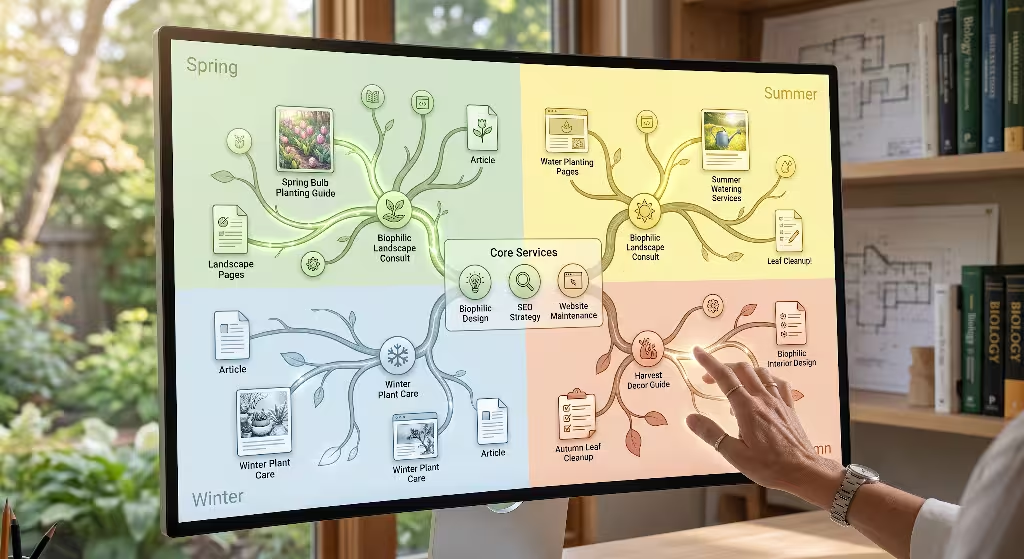
Phenology is the study of recurring biological events in nature, such as spring bird migrations, autumn leaf changes, or seasonal flower blooms. Connecting your internal linking strategy to these natural rhythms creates a dynamic, engaging website structure.
Current Environmental Event (Spring Runoff / Thaw)
                 |
                 v
   Live Species Feeds Flag Aquatic Insect Emergence
                 |
                 v
Dynamic Link: "Learn About Stream Restoration Services"
                 |
                 v
User Lands on High-Intent Commercial Service Page
As your live species feeds reflect seasonal milestones, you can automatically surface relevant articles and guides across your site:
- When feeds indicate early spring leaf-out, highlight educational guides on native tree care and wetland protection.
- When summer stream data shows rising water temperatures, share articles discussing the importance of shading stream banks with native riparian buffers.
- When autumn bird migrations appear in your feeds, recommend community stewardship projects and local conservation events.
This seasonal linking structure keeps your content timely and fresh. It guides visitors to valuable resources throughout the year while distributing internal page authority evenly across your website.
Measurement Framework: Tracking Crawl Health, Entity Associations, and Rank Improvements
To gauge the success of your live species feeds, establish a clear technical measurement plan. Monitor specific performance metrics over three to six months to track your progress:
+---------------------------+-----------------------------------+--------------------------+
| Metric Tracked            | Primary Monitoring Tool           | Success Indicator        |
|---------------------------|-----------------------------------|--------------------------|
| Bot Crawl Frequency       | Web Server Access Logs            | Increased daily visits   |
| Core Web Vitals Stability | Search Console Experience Reports | Fast LCP, Zero Layout Shifts|
| Entity Salience           | Natural Language Processing Tests | Strong watershed score   |
| Long-Tail Query Reach     | Search Console Performance Tabs   | More impressions on terms|
+---------------------------+-----------------------------------+--------------------------+
- Server Crawl Logs: Review your web server logs to track how often search engine bots visit your watershed pages. As you publish regular updates from live species feeds, you should see an increase in daily bot visits.
- Core Web Vitals Scores: Use Google Search Console to monitor page speed and visual stability, ensuring your media optimizations keep user experiences smooth and responsive.
- Entity Salience: Test your page content using natural language processing tools to confirm that search engines correctly associate your website with your target watershed and local waterways.
- Impression Growth for Long-Tail Terms: Track how often your pages appear for unique, highly specific searches regarding local wildlife, native plants, and regional water conditions.
By tracking these key metrics, you can refine your technical approach, optimize your data feeds, and ensure your site delivers lasting value to your community.
Technical Summary of Live Feeds Integration
[ Natural Ecosystem Activity ]
         |
         v
[ Open Science APIs: GBIF / iNaturalist / USGS ]
         |
         v
[ Edge Worker: Rate Limiting, Caching, and Image Compression ]
         |
         +---------------------------------------+
         |                                       |
         v                                       v
[ Machine-Readable JSON-LD Schema ]     [ Biophilic, Calm Web Interface ]
* Taxon Identification                  * Fast-Loading Images
* Hydrologic Unit Codes                 * Clear Ecological Status Cards
* Observation Timestamps                * Intuitive Internal Links
         |                                       |
         v                                       v
[ High Algorithmic Search Authority ]   [ Extended Human Dwell Time ]
         \                                       /
          +-------------------------------------+
                               |
                               v
             [ Long-Term Local Search Dominance ]
Integrating live species feeds into your local web architecture bridges the gap between digital development and the living world. By grounding your pages in natural catchments, respecting public scientific data sources, and presenting biological information with calm design clarity, you build a sustainable digital asset.
This biophilic approach improves search engine visibility, supports regional environmental awareness, and ensures your web platform stands out in today’s search landscape.